Sunday, July 29, 2012

July 14-19, 2012 Results -- Beastly Storms!

The long-range weather forecast for July 14-19, 2012 was posted on May 14th of this year. A number of predictions were made covering areas from the Lesser Antilles to New England. Some tropical activity was expected along with the possibility of other types of severe weather. Here's what happened. track_chart 
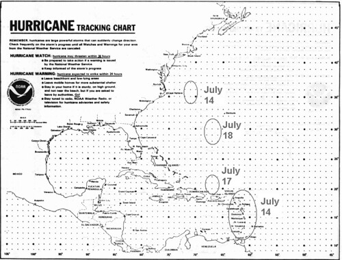
The above map was included with the forecast and showed the dates and places of possible tropical activity. I had circles the area over the Lesser Antilles and labeled it July 14th. Here's what the National Weather Service reported on this date: TROPICAL WAVE APPROACHING THE LESSER ANTILLES EXTENDS FROM 
20N60W TO 9N56W MOVING W NEAR 20 KT.

I also circled an area off the North Carolina and Virginia coasts to watch around the 14th as well. No tropical activity was reported although conventional meteorologists reported that North Carolina was the target for numerous thunderstorms on the 15th.

Around the 17th, I expected some sort of tropical activity just north of Hispaniola. On the 16th, the National Weather Service reported that a tropical wave was affecting the North Central Caribbean and the Bahamas. This wave along with daytime heating "HAS HELPED FORM CLUSTERS OF STRONG CONVECTION NEAR THE WAVE AXIS. ONE CLUSTER IS ACROSS HAITI FROM 18N-21N BETWEEN 72W-74W." This is basically the area mentioned in the forecast.   


On the 18th, I expected an area in and around 30 north latitude and 66-67 west longitude to produce some kind of tropical activity. Here's what the National Weather Service reported happening near there on the 18th.


AN UPPER LEVEL TROUGH IS TO THE E ALONG 30N62W TO AN UPPER LEVEL LOW IN 
THE CENTRAL CARIBBEAN. THE UPPER TROUGH SUPPORTS SOME ISOLATED
SHOWER/POSSIBLE THUNDERSTORMS FROM 120 NM EITHER SIDE OF A LINE
FROM HISPANIOLA TO 29N62W.

On the 19th it was over 29N65W. I, of course, was expecting stronger storm systems to manifest over these areas. So these tropical waves and upper level lows were small potatoes compared the storms that hit New England on the 17th and 18th. I had expected either a tropical system to lash the area or some other type of severe weather to do so. The Accuweather map below is for the 18th.
18 Vicious Storms

Accuweather said on the 17th that these beastly storms had the potential to produce intense gusts of wind, hail larger than quarters, and torrential, blinding downpours as well as perhaps spawn a tornado or two from New York state through New England. On the 18th, their headline ran: Vicious Storms Wednesday: Boston, NYC, Philly, DC.

Olympics Weather July 27- August 12, 2012
 Mars Conjunct Saturn August 15, 2012
Jupiter-Neptune and Heavy Rain
The Solar Eclipse of November 13, 2012
Long-range effects of the May 20, 2012 Solar Eclipse
Long-range effects of the May 20, 2012 Solar Eclipse Part 2
July 20-29, 2012 Long-range Weather Forecast
Hurricane Season 2011 Forecast Results
Hurricane Risk-Management
Texas Summer 2012
New Weather Alternative Website
Overview of UK Winter 2012-13
The Winters of 2011-14
Fulfilled Long-range Forecasts for Hurricane Season 2010
Introduction to the Weather Alternative

When you change the way you look at things, the things you look at change.” 
― Wayne W. Dyer

Saturday, July 21, 2012

Olympics Weather July 27- August 12, 2012

london6
The following forecasts are based on planetary cycles and are set for London, UK. Dates are approximate.


July 27-29: These days seem to indicate a windy weather pattern. There are a number of indications of a warm, southerly air flow indicating warm or hot temps. It's not clear how much precipitation is involved. A low or front may set up off the east coast of England.

July 31: Cool, dry weather

August 2: Fair

August 3: Increasing moisture brings a chance of rain. 

August 4: Southerly winds, rising temperatures. 

August 5: Fair conditions.  

August 6-9: Breezy to windy, warm, dry conditions. 

August 10-12: Southerly winds, warm temperatures, moderate humidity. 

Mars Conjunct Saturn August 15, 2012
Jupiter-Neptune and Heavy Rain
The Solar Eclipse of November 13, 2012
Long-range effects of the May 20, 2012 Solar Eclipse
Long-range effects of the May 20, 2012 Solar Eclipse Part 2
July 14-19, 2012 Hurricane Season Outlook
July 20-29, 2012 Long-range Weather Forecast
Hurricane Season 2011 Forecast Results
Hurricane Risk-Management
Texas Summer 2012
New Weather Alternative Website
Overview of UK Winter 2012-13
The Winters of 2011-14
Fulfilled Long-range Forecasts for Hurricane Season 2010
Introduction to the Weather Alternative

Sunday, July 15, 2012

Mars Conjunct Saturn August 15, 2012

Some of the most energetic weather patterns come on the heels of Mars-Saturn conjunctions. Windy, destructive storms attend the conjunction, parallel of declination, opposition, and square aspects. These are usually more intense during warm seasons. The next conjunction takes place on August 15, 2012. The last one formed on July 31, 2010. In this post, I'll look at four places that are affected by the next conjunction as well as upcoming dates when the Mars-Saturn conjunction should be spurred into action.

The first astro-locality map below shows Mars and Saturn affecting the 100th degree of west longitude running through the Plains and southward through Texas and Mexico. Two places stand out in particular. Mercury crosses Mars-Saturn over the Texas and Oklahoma panhandles, and, further south, the Moon crosses Mars and Saturn off the southern coast of Mexico approximately over 100 west longitude and 12 north latitude. So around the 15th of August we should see a severe weather pattern develop over the Plains with particular emphasis over the Texas and Oklahoma panhandles where destructive storms, perhaps generating hail, gusty winds, and tornadoes is possible. The crossing off the southern coast of Mexico should be watched around the 15th for the formation of tropical system.

US
The next map shows Mars and Saturn, represented by the white lines, crossing Mercury, shown by the blue line, over the North Sea between England and Denmark. Around the 15th of August, this area should respond with a vigorous low pressure system or strong front.

Europe
The third map shows a crossing between the Moon and Mars-Saturn around 175 east longitude and 27 south latitude. This lies about 725 miles north of New Zealand. This area should be watched for the formation or passage of a tropical cyclone around the 15th of August.

  New Zealand
Activation Dates

The Mars-Saturn conjunction will be triggered on the following dates:
Sept 1, 2012
Oct 1, 2012
Oct 17, 2012
Nov 17, 2012

Although all four places discussed will be triggered on these dates and should respond with varying degrees of severe weather, here is a more detailed look at some of the activation dates.

Aug 29-Sept 2, 2012
The crossings over Mexico and New Zealand are activated now by Saturn and Venus.

Aug 30-Sept 2, 2012
The crossings over Texas/Oklahoma and Europe are emphasized now as Mars and Venus trigger them.

Oct 1-3, 2012
The Mexico and New Zealand crossings appear to be more active than the others due to Mercury's triggers.

Oct 17-19, 2012
The Mexico and New Zealand crossings once again receive more activation by the transit Sun.

Nov 17-19, 2012
Venus triggers the Mars-Saturn conjunction and gives extra energy to the Mexico and New Zealand crossings.

Jupiter-Neptune and Heavy Rain
Long-range effects of the May 20, 2012 Solar Eclipse
July 14-19, 2012 Hurricane Season Outlook
Hurricane Season 2011 Forecast Results
Hurricane Risk-Management
Texas Summer 2012
New Weather Alternative Website
Overview of UK Winter 2012-13
The Winters of 2011-14
Fulfilled Long-range Forecasts for Hurricane Season 2010
Introduction to the Weather Alternative

When and How did the Universe Begin?

Tuesday, July 10, 2012

Jupiter-Neptune and Heavy Rain

In recent posts I've talked about the effect of the Jupiter-Neptune square of June 25, 2012 and the Uranus-Pluto square of June 24, 2012. I've mentioned how one of the main influences of Jupiter-Neptune pertains to heavy rainfall. Here's another look at how this has played itself out since the square took place at the end of June and some dates and places where the effects should manifest again in the future.

One area that was directly affected by the Jupiter-Neptune square was the Philippine Islands. As can be seen from the astro-locality map below, the two planets crossed over the Philippines on June 25th at the time of the exact square. Phil

The very next day, Accuweather reported that Tropical Depression Doksuri formed east of the Philippines and would bring locally heavy rain to the islands as it made its way towards Hong Kong. The National Weather Service map below shows Doksuri affecting the islands on the 27th of June. 553285_321436724611891_604511869_n

Another important crossing occurred over eastern Canada between the Sun and Neptune as shown in the next astro-locality map. Newfoundland

On the 26th, this area of New England and eastern Canada was hit by heavy rainfall as shown in the map below. 26 Maine

Accuweather reported on the 26th that enough rain would fall on Maine and neighboring Canada on the 26th and 27th to cause localized flooding problems. The storm system was tapping into some tropical moisture from Debby which helped bring the drenching rain. As I pointed out in another post, the Uranus-Pluto square was also operating over this area and was also a contributor to the weather pattern.

The Jupiter-Neptune square will be triggered in upcoming months and we should look to these same areas--the Philippines and New England-Eastern Canada-- for reactions that also bring heavy rain although we should not expect a tropical depression in every case. Here are some dates when we could expect such weather.

August 25, 2012
September 2, 2012
October 5, 2012
October 11, 2012
November 2, 2012
November 10, 2012
November 24, 2012

Long-range Effects of the May 20, 2012 Solar Eclipse Part 2
Long-range effects of the May 20, 2012 Solar Eclipse
July 14-19, 2012 Hurricane Season Outlook
Hurricane Season 2011 Forecast Results
Hurricane Risk-Management
Texas Summer 2012
New Weather Alternative Website
Overview of UK Winter 2012-13
The Winters of 2011-14
Fulfilled Long-range Forecasts for Hurricane Season 2010
Introduction to the Weather Alternative

Faith expects from God what is beyond all expectation-- Andrew Murray

Sunday, July 01, 2012

TS Debby and June 22-30, 2012 Forecast Results

The original forecast was posted on May 7, 2012 and mainly focused on the effects of the approaching Uranus-Pluto and Jupiter-Neptune alignments on weather patterns. Although Jupiter-Neptune did not disappoint us as far as its potential for instigating tropical systems (Tropical Storm Debby), it did not correspond to an increase in moisture over the Plains and Mississippi Valley as I was expecting. In another post, I will delve into the Jupiter-Neptune square a bit more and offer some dates and locations that will experience their effect in the future.

The main event over the Plains and Mississippi Valley during the forecast period (June 22-30) was a heat wave breaking all-time records with triple-digit temperatures and gusty winds. How is this at all like Jupiter-Neptune's influence which is supposed to bring low pressure areas and increased precipitation? Well, according to G.J. McCormack, the 20th Century's most accurate and famous astrometeorologist, those are not the only manifestations of Jupiter-Neptune. According to McCormack we can also count on excessive humidity and higher ranges of temperature. This is more like what we got over the Central U.S. at that time. I should have included these other standard possibilities in the forecast.

Tropical Storm Debby

TS Debby formed right at the time of the Uranus-Pluto square (June 24) and the Jupiter-Neptune square (June 25). I believe the most important chart that accounts for Debby's track across northern Florida is the recent Solar Eclipse chart of May 20, 2012. Neptune and Jupiter made an important crossing right over the South Carolina-Georgia coasts at that time and we've seen a number of tropical systems form there (TS Alberto and TS Beryl) since the eclipse. My take is that Debby was being drawn toward that point. Here's the astro-locality map that shows the crossing over South Carolina and Georgia.

Eclipse

And here's the map of the track that conventional forecasters eventually decided on. 25 Debby Track

Conventional forecasters at first were a bit perplexed not knowing whether Debby would head west toward Mississippi and Louisiana or cut across Florida and head into the Atlantic. Here's their map for Debby's track issued the day before the one above.
24 TS Debbie

In my forecast, I mentioned Mississippi for severe weather at this time and on the 24th Debby was affecting as far west as Mississippi fulfilling that forecast. The National Weather Service reported that convection from Debby was not only affecting the Florida Peninsula but westward to 88 west longitude, which is in and around Mississippi.

On the other side of Florida, I mentioned that the New Moon Chart places a crossing near the Bahamas and that tropical activity may be possible there.
Jupiter Neptune


When you look at the New Moon's Jupiter-Neptune crossing and compare it with a satellite picture for the 25th, you can see how Debby's influence extended to that very area. So these astro-influences account for conventional forecasters' east-west track dilemma.


25 Tropics

I also mentioned an area off the south coast of Mexico where tropical storm formation was possible. There was a report by the Weather Channel on the 21st, stating, "A low pressure system continues focusing "Equatorial Express" moisture into the Pacific coast of Mexico with an ongoing threat of flash flooding and mudslides/landslides."

Uranus-Pluto

This forecast pinpointed the New England area for severe weather. On the 25th heavy rain hit New England and on the 26th the Accuweather headline stated Maine Rain Bringing Localized Flooding. Here's the Accuweathe map for the 26th.

26 Maine

The last portion of the forecast called for possible tropical storm development about 750 miles west of Cabo San Lucas. No storm formation was reported.

Long-range Effects of the May 20, 2012 Solar Eclipse Part 2
Long-range effects of the May 20, 2012 Solar Eclipse
July 14-19, 2012 Hurricane Season Outlook
Hurricane Season 2011 Forecast Results
Hurricane Risk-Management
Texas Summer 2012
New Weather Alternative Website
Overview of UK Winter 2012-13
The Winters of 2011-14
Fulfilled Long-range Forecasts for Hurricane Season 2010
Introduction to the Weather Alternative

Truth and Error

Error does not become Truth because it is widely accepted;
Truth does not become error, even when it stands alone!